Abstract
This study was conducted over a 34 km2 area in the Ferlo region (northern Senegal). It aims to analyze the spatio-temporal dynamics of tree vegetation and the distribution of temporary ponds. The ponds were identified using satellite images acquired in September 2015 (rainy season), while woody vegetation was mapped for two periods: April 1972 and May 2016 (dry season), enabling a diachronic analysis over 44 years. The data were extracted from very high spatial resolution satellite images (<3 m): SPOT 6-7 for 2015-2016 and CORONA for 1972. Image processing (ortho-rectification, enhancement, automatic detection, mapping) enabled the creation of accurate maps, which were then analyzed according to the principles of landscape ecology using the open-source software R, GRASS 7.6, and QGIS 3.4. A total of 244 ponds were automatically detected, representing 1.29% of the study area (43.4 ha), organized in a NE-SW alignment. Diachronic analysis shows a significant collapse in tree cover between 1972 (12.3%) and 2016 (2%). However, this decline is not observed in ponds, where woody cover has remained stable. Between 1972 and 2016, the Ferlo ponds showed a significant improvement in vegetation cover: while half of the ponds had less than 55% cover in 1972, this value exceeded 60% in 2016. These results shed new light on the distribution of vegetation in Ferlo and highlight the central ecological role of ponds in plant resilience in the Sahel.
Keywords
Remote Sensing, Mapping, Woody Dynamics, Landscape Ecology, Sahelian Wetlands
1. Introduction
The Ferlo region, like other Sahelian areas, is particularly vulnerable to climate change. For several decades, recurring episodes of drought combined with increasing anthropogenic pressure have profoundly altered the living conditions of local populations and affected the regional economy
| [1] | Diouf, M., Akpo, L.-E., Rocheteau, A., Do, F., & Diagne, A. L. (2002). Dynamique Du Peuplement Ligneux D’une Vegetation Sahelienne Au Nord-Senegal (Afrique De L’ouest). Journal des Sciences, 2, 10. |
[1]
.
The high interannual variability of rainfall makes pastoralism, a dominant activity in Ferlo, particularly precarious
| [2] | Diop, A. T., Diaw, O. T., Dieme, I., Toure, I., Sy, O., & Dieme, G. (2004). Mares de la zone sylvo-pastorale du Senegal: Tendances evolutives et rôle dans les strategies de production des populations pastorales. Revue d’elevage et de medecine veterinaire des pays tropicaux, 57(1‑2), 77.
https://doi.org/10.19182/remvt.9910 |
| [3] | Diop, A. T., Diaw, O. T., Thiam, M., Dieme, I., Toure, I., Dieme, G., & Traore, M. (2004). Les mares de la Zone sylvopastorale du Senegal: rôle dans la conservation de la biodiversite et du cadre de vie des populations pastorales. 8. |
| [4] | Sy, O. (2009). Rôle de la mare dans la gestion des systèmes pastoraux saheliens du Ferlo (Senegal). Cybergeo : European Journal of Geography, 440, pp 1‑11.
https://doi.org/10.4000/cybergeo.22057 |
[2-4]
. This has resulted in the massive death of trees and shrubs during the most severe rainfall deficits
| [5] | Charmard, PH. C., & Courel, M. F. (1999). La forêt sahelienne menacee. Secheresse, 10(1), pp 11‑18. |
| [6] | Toure, A. A., Guillon, R., Garba, Z., Rajot, J.-L., Petit, C., Bichet, V., Durand, A., & Sebag, D. (2010). Evolution des paysages Saheleines au cours des six dernières decennies dans la region de Niamey: de la disparition de la brousse tigree à l’encroutement de surface des sols. Sahelian landscape evolution during the six last decades in the Niiamey vicinity: from the tiger bush disappearing to the soil crusting. Pangea, 47(48), pp 35‑40. |
[5, 6]
.
In this context of ecological degradation, temporary ponds play an essential role
| [2] | Diop, A. T., Diaw, O. T., Dieme, I., Toure, I., Sy, O., & Dieme, G. (2004). Mares de la zone sylvo-pastorale du Senegal: Tendances evolutives et rôle dans les strategies de production des populations pastorales. Revue d’elevage et de medecine veterinaire des pays tropicaux, 57(1‑2), 77.
https://doi.org/10.19182/remvt.9910 |
[2]
. They contribute to the well-being of local communities by providing water, fodder resources, fruit, and areas of shade and rest for livestock. These ponds also provide ideal habitats for abundant, diverse, and sometimes rare flora
| [7] | Jourdas, A. (2013). Comprendre la mare à travers sa biodiversite. (VALMARES, UN PROJET AUTOUR DES MARES). |
[7]
, and contribute to the socio-environmental resilience of the territories.
However, these aquatic ecosystems are under double pressure: on the one hand, the reduction in the frequency and duration of flooding due to climate change; on the other hand, the intensification of human use around these water sources. Hence the need to better understand the spatio-temporal dynamics of ponds and their associated vegetation over the last few decades.
This study is part of this project. It aims to map and analyze the dynamics of woody vegetation in and around the Ferlo ponds over a period of 44 years (1972 to 2016). The objective is to measure the degree of degradation of tree cover, identify explanatory factors, and assess the specific resilience of wetlands. By adopting a diachronic approach based on very high-resolution satellite data, this work contributes to improving our understanding of the interactions between landscape structures, edaphic conditions, and woody vegetation dynamics.
This methodological choice is justified by the limitations of global vegetation cover maps, which are often unsuitable for the fine scales of regional ecological analyses
| [8] | Vierling, K. T., Vierling, L. A., Gould, W. A., Martinuzzi, S., & Clawges, R. M. (2008). Lidar: Shedding new light on habitat characterization and modeling. Frontiers in Ecology and the Environment, 6(2), pp 90‑98. https://doi.org/10.1890/070001 |
| [9] | Alexander, C., Bøcher, P. K., Arge, L., & Svenning, J.-C. (2014). Regional-scale mapping of tree cover, height and main phenological tree types using airborne laser scanning data. Remote Sensing of Environment, 147, pp 156‑172.
https://doi.org/10.1016/j.rse.2014.02.013 |
[8, 9]
. For this reason, specific aerial and satellite images (CORONA and SPOT 6-7) were used to meet the spatial and temporal accuracy requirements of the study.
2. Methodology
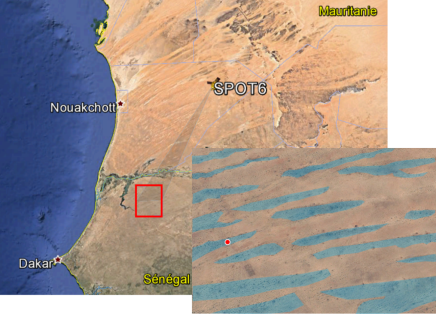
(1) Presentation of the Study Area
The study was conducted in the Ferlo region of northern Senegal, specifically in the village of Widou Thiengoly (15°58'30'‘N, 15°17'90’'W) (
Figure 1). This location was chosen for its high concentration of temporary ponds, the diversity of their forms, intense pastoral pressure, and the presence of the Great Green Wall (GGW) route, accompanied by several environmental projects.
The climate is arid Sahelian, with a dry season lasting nine months (October to June) and a short rainy season lasting three months (July to September). Average annual rainfall over the last fifty years is 371.67 mm, with an average temperature of around 27.73°C
| [10] | Ndiaye, O, Diop, A., Diène, M., & Akpo, L. (2015). Etude comparee de la vegetation de 1964 et 2011 en milieu pâture: Cas du CRZ de Dahra. Journal of Applied Biosciences, 88(1), 8235. https://doi.org/10.4314/jab.v88i1.8 |
| [11] | Ndiaye, Ousmane, Aly, D., Bassimbe, S. M., & Aliou, G. (2013). Diversite floristique des peuplements ligneux du Ferlo, Senegal. VertigO, 13(3), 1‑2.
https://doi.org/10.4000/vertigo.14352 |
[10, 11]
.
The terrain is relatively flat and consists of tropical sandy soils that are poor in clay, which limits the development of a structured hydrographic network. During the rainy season, these conditions favor the formation of numerous endorheic ponds, which are characteristic of the landscape.
The vegetation takes the form of shrubby to wooded steppe, dominated by species such as
Balanites aegyptiaca, Acacia tortilis subsp. raddiana, and Acacia senegal for the tree layer,
Calotropis procera and
Boscia senegalensis for the shrub layer, and a diversity of grasses and annual herbaceous plants in the rainy season
| [12] | Akpo, L. (1992). Influence du couvert ligneux sur la structure et le fonctionnement de la strate herbacee en milieu sahelien [Thèse de Doctorat de 3eme cycle de Biologie Vegetale]. UCAD. |
| [13] | Niang, Khoudia. (2009). L’arbre dans les parcours communautaires du Ferlo-Nord (Senegal) (p. 68) [MEMOIRE D’ETUDE APPROFONDIE (DEA) DE BIOLOGIE VEGETALE]. Laboratoire d’ecologie vegetale et d’eco-hydrologie. |
| [14] | Niang, K, Ndiaye, O., Diallo, A., & Guisse, A. (2014). Flore et structure de la vegetation ligneuse le long de la Grande Muraille Verte au Ferlo, nord Senegal. Journal of Applied Biosciences, 79(1), pp 6938 – 6946.
https://doi.org/10.4314/jab.v79i1.15 |
[12-14]
.
The study area covers 3,360 ha and is distinguished by the diversity of its ecological environments: dunes, interdune areas, wetlands, and plots reforested under the GGW (since 2008).
(2) Geospatial Data Used
The approach is based on the combined use of aerial photographs and high spatial resolution satellite images:
1) CORONA images from 1972, panchromatic (resolution of 1.8 m), used to reconstruct historical woody vegetation. These images, originally intended for military observation between July 1960 and May 1972, were declassified in 1995 and are now available through the USGS
| [15] | Tappan, G. G., Hadj, A., Wood, E. C., & Lletzow, R. W. (2000). Use of Argon, Corona, and Landsat Imagery to Assess 30 Years of Land Resource Changes in West-Central Senegal. Photogrammetric Engineering & Remote Sensing, 66(6), pp 727‑735. |
| [16] | Altmaier, A., & Kany, C. (2002). Digital surface model generation from CORONA satellite images. ISPRS Journal of Photogrammetry and Remote Sensing, 56(4), pp 221‑235.
https://doi.org/10.1016/S0924-2716(02)00046-1 |
| [17] | Challis, K., Priestnall, G., Gardner, A., Henderson, J., & O’Hara, S. (2004). Corona Remotely-Sensed Imagery in Dryland Archaeology: The Islamic City of al-Raqqa, Syria. Journal of Field Archaeology, 29(1‑2), pp 139‑153. |
| [18] | Song, D.-X., Huang, C., Sexton, J. O., Channan, S., Feng, M., & Townshend, J. R. (2015). Use of Landsat and Corona data for mapping forest cover change from the mid-1960s to 2000s: Case studies from the Eastern United States and Central Brazil. ISPRS Journal of Photogrammetry and Remote Sensing, 103, pp 81‑92. https://doi.org/10.1016/j.isprsjprs.2014.09.005 |
[15-18]
.
2) SPOT 6-7 images, acquired in September 2015 (rainy season) and May 2016 (dry season), at resolutions of 6 m in multispectral and 1.5 m in panchromatic. These data were provided by Equipex GEOSUD (Remote Sensing Center, Montpellier), as part of the UMI3189 Sahelian program. Stereoscopic coverage of 3,600 km2 centered on Widou Thiengoly was obtained.
The spectral bands used for SPOT include blue, green, red, and near-infrared (NIR), enabling the detection of vegetation and soil moisture (
Table 1).
Table 1. Images and their resolutions.
Images | Bands or channels | Wavelength (μm) | Name | Dates | Resolution (m) |
SPOT 6-7 | Band 3 | 0.455-0.525 | Blue (B) | 2015 – 2016 | 6 |
Band 2 | 0.530-0.590 | Green (G) | 2015 – 2016 | 6 |
Band 1 | 0.625-0.695 | Red (R) | 2015 – 2016 | 6 |
Band 4 | 0.760-0.890 | Near Infrared (NIR) | 2015 – 2016 | 6 |
Mono-spectral | 0.455-0.745 | Panchromatic (P) | 2015 – 2016 | 1.5 |
CORONA | - | - | Panchromatic (P) | 1966 | 1.8 |
- | - | Panchromatic (P) | 1972 | 1.8 |
(3) Image Preprocessing and Processing
The images underwent several processing steps to extract relevant information:
1) Ortho-rectification: geometric correction of images for rigorous spatial alignment.
2) Image enhancement: contrast adjustment, noise filtering, and panchromatic/multispectral fusion.
3) Automatic object detection: extraction of ponds and woody plants using classification algorithms.
4) Mapping: creation of fine-scale GIS layers, integrated into a spatial database.
The open-source software GRASS GIS 7.6 and QGIS 3.4 were used for all spatial processing and analysis.
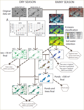
(4) Landscape Analysis
The analysis used landscape ecology concepts and tools to characterize the distribution of ponds and woody plants (
Figure 2). An unsupervised classification (K-means) was performed using the 2015 Blue, Green, and Near-Infrared (NIRGB) image to differentiate four types of environments according to their hydromorphic potential:
1) Dry areas,
2) Intermediate areas (good herbaceous cover),
3) Wet areas (high soil moisture),
4) Ponds (presence of open water or very high moisture).
This classification enabled the spatialization of habitat types and the analysis of the tree cover associated with each.
Figure 2. Process for detecting woody vegetation and ponds.
3. Results
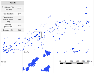
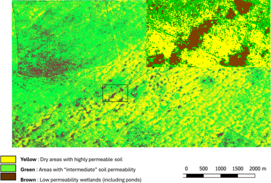
(1) Spatial Organization of Ponds
Analysis of satellite images from September 2015 enabled detailed mapping of ponds in the study area. The results reveal a non-random pattern: the 244 ponds identified are aligned in a northeast/southwest (NE-SW) direction, arranged in parallel bands spaced 300 to 500 m apart. These bands are separated by sandy interfluves of dune origin.
The ponds cover a total area of 43.4 ha, or 1.29% of the total area of the study zone (3,360 ha). This spatial distribution reflects the influence of paleotopography, particularly ancient dune systems, on the location of hydromorphic depressions (
Figure 3).
Figure 3. Spatial organization of ponds (A) across the entire study window; (B) zoom on a group of ponds.
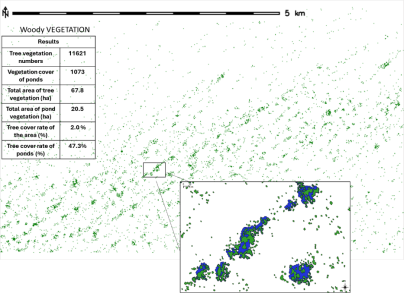
(2) Current Distribution of Vegetation Cover
The woody vegetation map (image 2016 (
Figure 4)) shows uneven distribution across the study area. Tree densities are low in the northwest and southeast corners and higher in the central strip where ponds are concentrated. Statistical analysis indicates that 67.8 ha are covered by woody plants, including 20.5 ha located in ponds.
This means that 30.3% of the detected vegetation cover is found in ponds, which occupy only 1.29% of the area, highlighting their crucial role in the conservation of woody plants.
Figure 4. Mapping of woody plants in the study area and in ponds.
(3) Hydromorphic Typology and Woody Cover
Based on the 2015 NIRVB image, four classes of environments were distinguished according to their hydromorphic potential:
1) Dry areas: not very conducive to herbaceous and tree growth.
2) Intermediate areas: moderate herbaceous development.
3) Wet areas: good conditions for plant growth.
4) Ponds: high humidity or presence of open water.
The map produced from this classification (
Figure 5) confirms that ponds are the most wooded environments, followed by wet areas (
Table 2). Dry areas have very low woody cover (0.9%).
Figure 5. Map of the four zones according to their hydromorphic potential (ponds and wetlands in brown, intermediate zones in green, and dry zones in yellow).
Table 2. Tree cover by type of environment (2016).
Type of environment | Area (ha) | Wooded area (ha) | Recovery rate (%) |
Study area | 3360.0 | 67.8 | 2.0% |
Ponds | 43.4 | 20.5 | 47.3% |
Wetlands | 331.5 | 21.8 | 6.6% |
Intermediary areas | 1736.8 | 34.6 | 2.0% |
Dry areas | 1286.4 | 11.3 | 0.9% |
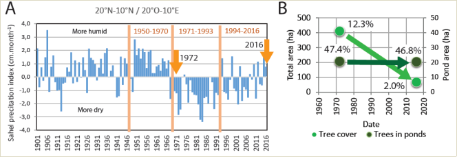
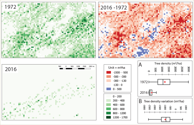
(4) Diachronic Evolution of Woody Vegetation (1972–2016)
A comparison of CORONA images from 1972 and SPOT images from 2016 shows a sharp decline in tree cover across the entire study area: from 12.3% in 1972 to 2% in 2016. This sharp decline coincides with the major droughts that have affected the Sahel since the 1970s (
Figure 6A).
However, the situation is different in the ponds: unlike the rest of the territory, tree cover there has remained broadly stable (
Figure 6B and
Figure 7).
Figure 7. Map of woody plant density.
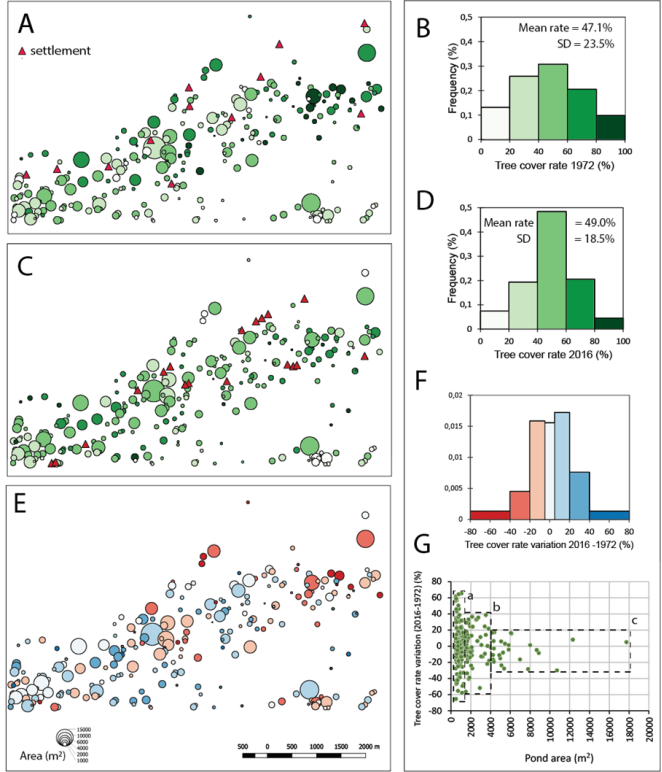
(5) Specific Analysis of Evolution in Ponds
The distribution of ponds according to their woody vegetation cover shows an increase between 1972 and 2016 (
Figure 8A and B). In 1972 (
Figure 8C and D), half of the ponds had a canopy cover of less than 55%, while in 2016, half exceeded 60%. This confirms that ponds are hubs of ecological resilience, maintaining conditions favorable to the development of tree cover (
Figure 8).
The pond distribution map illustrates three major trends:
1) Southern part of the area: small ponds with significant tree covers growth.
2) Center: medium or large ponds with stable coverage.
3) Northwest: large ponds with significant degradation of vegetation cover.
These changes appear to be related to the size of the ponds, their location, and their degree of isolation or proximity to settlements.
Figure 8. Histogram of vegetation coverage rates for ponds (N=244) and Distribution of ponds.
(6) Influence of Human Pressures
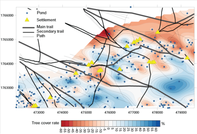
Observations of the spatial structure of the degradation/preservation of tree cover around ponds reveal the existence of pond clusters (
Figure 8E). A “kriging” technique applied to the values and positions of variations in tree cover density around ponds makes it possible to specify the shape and location of these clusters (
Figure 9).
A final analysis incorporated traffic routes (main, secondary, and tertiary roads) and the location of settlements into the mapping. Ponds with degraded vegetation are generally close to these infrastructures. Conversely, the best-preserved ponds appear more isolated, far from inhabited or frequented areas (
Figure 8).
This observation supports the hypothesis that anthropogenic pressure (overgrazing, trampling, wood collection) is a major factor in the degradation of woody cover around ponds.
Figure 9. Spatial analysis using kriging of the rates of change in tree cover over ponds (2016) and overlay with settlements and transport routes.
4. Discussion
Spatio-temporal analysis of the dynamics of ponds and woody vegetation in the Ferlo study area has provided a better understanding of the ecological structure of this Sahelian environment. The results confirm the vulnerability of woody vegetation to climatic and anthropogenic stresses, while highlighting the protective and resilient function of ponds.
The degradation of vegetation cover is evident throughout the study area: tree cover has declined from 12.3% in 1972 to 2% in 2016, corroborating the findings of numerous studies on the cumulative effects of prolonged droughts in the Sahel
| [19] | Brandt, M., Romankiewicz, C., Spiekermann, R., & Samimi, C. (2014). Environmental change in time series – An interdisciplinary study in the Sahel of Mali and Senegal. Journal of Arid Environments, 105, pp 52‑63.
https://doi.org/10.1016/j.jaridenv.2014.02.019 |
| [20] | Brandt, M., Tappan, G., Diouf, A., Beye, G., Mbow, C., & Fensholt, R. (2017). Woody Vegetation Die off and Regeneration in Response to Rainfall Variability in the West African Sahel. Remote Sensing, 9(1), 39.
https://doi.org/10.3390/rs901003 |
| [21] | Spiekermanna, R., Brandt, M., & Samimi, C. (2015). Woody vegetation and land cover changes in the Sahel of Mali (1967–2011). International Journal of Applied Earth Observation and Geoinformation, 34, pp 113‑121.
https://doi.org/10.1016/j.jag.2014.08.007 |
[19-21]
. This reduction in tree cover is particularly marked in dry and intermediate areas, which have low hydromorphic potential and are not conducive to natural regeneration.
In contrast, the dynamics observed in temporary ponds show a completely different trajectory: vegetation cover remained stable or even increased slightly between 1972 and 2016, reaching 47.3% in 2016. This specificity can be explained by the particular edaphic conditions of ponds, which are favorable to the establishment and growth of woody plants: water availability, accumulation of organic matter, and better protection from wind and livestock.
Our results are consistent with those of Lacaux and the others
| [22] | Lacaux, J. P., Tourre, Y. M., Vignolles, C., Ndione, J. A., & Lafaye, M. (2007). Classification of ponds from high-spatial resolution remote sensing: Application to Rift Valley Fever epidemics in Senegal. Remote Sensing of Environment, 106(1), 66‑74. https://doi.org/10.1016/j.rse.2006.07.012 |
[22]
, who identified a high concentration of endorheic ponds in the Ferlo region. Our own inventory (244 ponds covering 43.4 ha) corresponds to a coverage of 1.29%, slightly more than the 0.9% reported in a larger area by the same authors. This abundance of ponds is linked to the region's paleo-topography of dunes, whose NE-SW oriented depressions favor their formation and alignment.
Furthermore, a correlation has been observed between the size of ponds and changes in their vegetation: small ponds (<0.5 ha) located in the south often have high coverage rates, while larger ponds located in the northwest show degradation of woody cover. These differences can be interpreted as reflecting a natural process of pond evolution, leading gradually to filling and colonization by tree species
| [23] | Guitte, V., Laporte, M., Seguin, S., & Zimolo, A. (2015). Prendre en compte la preservation des mares dans la gestion forestière. SNPN/ CRPF. |
[23]
. However, this pattern is not universal: in some regions of the Sahel, such as the Gourma region of Mali, Gardelle and the others
| [24] | Gardelle, J., Hiernaux, P., Kergoat, L., & Grippa, M. (2010). Less rain, more water in ponds: a remote sensing study of the dynamics of surface water from 1950 to present in pastoral Sahel (Gourma region, Mali). Hydrology and Earth System Sciences, European Geosciences Union, 14(2), pp 309-324. |
[24]
observed an expansion of certain large ponds over the decades in response to specific local dynamics.
Another determining factor identified is anthropogenic pressure
| [25] | Faye, N., Diallo, A., Sagna, M. B., Sarr, O., Talla, R., Badji, E. S., Peiry, J. L., & Guisse A. (2020). Repartition spatiale de la vegetation herbacee autour des mares temporaires: Influence des facteurs anthropiques et topographiques à WIDOU THIENGOLY (Ferlo, Nord-Senegal). International Journal of Biological and Chemical Sciences, 14(6), 2077–2093.
https://doi.org/10.4314/ijbcs.v14i6.12 |
| [26] | Faye, N., Diallo, A., Sagna, M. B., Sarr, P. S., Peiry, J. L., & Guisse A. (2021). Influence of anthropic and eco-hydrological factors on the floristic diversity of the herbaceous vegetation around the temporary ponds in Ferlo, Northern Senegal. Journal of Plant Ecology, 15(1), 26-38.
https://doi.org/10.1093/jpe/rtab053 |
[25, 26]
. Pools located near camps or tracks generally have lower or stagnant tree cover rates, probably due to their intensive use for watering, overgrazing, or wood harvesting. Conversely, isolated pools appear to be better preserved, which is consistent with the conclusions of
| [27] | Kaptue, A. T., Prihodko, L., & Hanan, N. P. (2015). On regreening and degradation in Sahelian watersheds. Proceedings of the National Academy of Sciences, 112(39), pp 12133–12138. https://doi.org/10.1073/pnas.1509645112 |
[27]
, who emphasize that ecological resilience is often stronger in areas with low human density.
Finally, field observations reveal that some ponds are subject to regulated use, particularly by populations who reserve their use for humans at the beginning of the rainy season, thus temporarily protecting the vegetation. This behavior reflects a local awareness of the ecological value of ponds, which should be reinforced through awareness-raising and concerted management actions.
5. Conclusion
This study assessed the spatio-temporal dynamics of woody vegetation and temporary ponds in a Sahelian portion of Ferlo, northern Senegal, between 1972 and 2016. Using old and recent satellite images (CORONA, SPOT 6-7), combined with remote sensing and landscape ecology tools, it was possible to map plant and hydromorphic structures in detail and analyze their evolution.
The main findings show:
1) A sharp decline in tree covers across the entire area, with coverage falling from 12.3% to 2% in 44 years;
2) Stable or even slightly increased vegetation in ponds, which account for more than 30% of total tree cover despite occupying only 1.29% of the area;
3) A structured spatial organization of ponds in NE-SW bands, linked to the paleo-topography of the dunes;
4) A marked influence of the size of the ponds, their location, and the proximity of camps and infrastructure on their vegetation dynamics.
These results highlight the central role of ponds in the conservation of woody vegetation in the Sahel. As reservoirs of moisture, they are essential ecological refuges, contributing to the resilience of landscapes in the face of climatic and human stresses.
In the context of the progressive degradation of Sahelian ecosystems, it is becoming essential to:
1) Strengthen the protection of ponds and their immediate surroundings against excessive anthropogenic pressures;
2) Integrate ponds into sustainable land management strategies, particularly within the Great Green Wall projects;
3) Conduct further research into their ecological functioning, biodiversity, and role in woody recolonization dynamics.
In short, ponds are not simply temporary water sources: they must be recognized as structuring elements of the Sahelian landscape, with high ecological, social, and strategic value.
Abbreviations
GGW | Great Green Wall |
NIR | Near Infrared |
NIRGB | Blue, Green, and Near-Infrared |
OHMi | Observatoire homme-Milieu international |
SPOT | Satellite Pour observation de la Terre |
UMI3189 | Unite Mixte de Recherche Internationale 3189 |
Acknowledgments
We would like to thank the « Remote Sensing Center » in Montpellier for providing the SPOT 6 and 7 satellites images used in this research, and Tessekere's “Observatoire homme-Milieu international (OHMi)” project for providing logistical support.
Author Contributions
Ndiabou Faye: Conceptualization, Data curation, Investigation, Methodology, Software, Writing – original draft, Writing – review & editing
Ramata Talla: Investigation, Validation, Visualization, Writing – review & editing,
Aissatou Thiam Ndong: Validation, Visualization, Writing – review & editing,
Moustapha Bassimbe Sagna: Validation, Visualization, Writing – review & editing
Diara Sylla: Validation, Visualization, Writing – review & editing
Aly Diallo: Validation, Visualization, Writing – review & editing
Oumar Sarr: Validation, Visualization, Writing – review & editing
Aliou Guisse: Funding acquisition, Project administration, Resources, Supervision
Jean-Luc Peiry: Investigation, Methodology, Supervision, Funding acquisition, Project administration, Resources, Validation, Visualization, Writing – review & editing
Conflicts of Interest
The authors declare no conflicts of interest.
References
| [1] |
Diouf, M., Akpo, L.-E., Rocheteau, A., Do, F., & Diagne, A. L. (2002). Dynamique Du Peuplement Ligneux D’une Vegetation Sahelienne Au Nord-Senegal (Afrique De L’ouest). Journal des Sciences, 2, 10.
|
| [2] |
Diop, A. T., Diaw, O. T., Dieme, I., Toure, I., Sy, O., & Dieme, G. (2004). Mares de la zone sylvo-pastorale du Senegal: Tendances evolutives et rôle dans les strategies de production des populations pastorales. Revue d’elevage et de medecine veterinaire des pays tropicaux, 57(1‑2), 77.
https://doi.org/10.19182/remvt.9910
|
| [3] |
Diop, A. T., Diaw, O. T., Thiam, M., Dieme, I., Toure, I., Dieme, G., & Traore, M. (2004). Les mares de la Zone sylvopastorale du Senegal: rôle dans la conservation de la biodiversite et du cadre de vie des populations pastorales. 8.
|
| [4] |
Sy, O. (2009). Rôle de la mare dans la gestion des systèmes pastoraux saheliens du Ferlo (Senegal). Cybergeo : European Journal of Geography, 440, pp 1‑11.
https://doi.org/10.4000/cybergeo.22057
|
| [5] |
Charmard, PH. C., & Courel, M. F. (1999). La forêt sahelienne menacee. Secheresse, 10(1), pp 11‑18.
|
| [6] |
Toure, A. A., Guillon, R., Garba, Z., Rajot, J.-L., Petit, C., Bichet, V., Durand, A., & Sebag, D. (2010). Evolution des paysages Saheleines au cours des six dernières decennies dans la region de Niamey: de la disparition de la brousse tigree à l’encroutement de surface des sols. Sahelian landscape evolution during the six last decades in the Niiamey vicinity: from the tiger bush disappearing to the soil crusting. Pangea, 47(48), pp 35‑40.
|
| [7] |
Jourdas, A. (2013). Comprendre la mare à travers sa biodiversite. (VALMARES, UN PROJET AUTOUR DES MARES).
|
| [8] |
Vierling, K. T., Vierling, L. A., Gould, W. A., Martinuzzi, S., & Clawges, R. M. (2008). Lidar: Shedding new light on habitat characterization and modeling. Frontiers in Ecology and the Environment, 6(2), pp 90‑98.
https://doi.org/10.1890/070001
|
| [9] |
Alexander, C., Bøcher, P. K., Arge, L., & Svenning, J.-C. (2014). Regional-scale mapping of tree cover, height and main phenological tree types using airborne laser scanning data. Remote Sensing of Environment, 147, pp 156‑172.
https://doi.org/10.1016/j.rse.2014.02.013
|
| [10] |
Ndiaye, O, Diop, A., Diène, M., & Akpo, L. (2015). Etude comparee de la vegetation de 1964 et 2011 en milieu pâture: Cas du CRZ de Dahra. Journal of Applied Biosciences, 88(1), 8235.
https://doi.org/10.4314/jab.v88i1.8
|
| [11] |
Ndiaye, Ousmane, Aly, D., Bassimbe, S. M., & Aliou, G. (2013). Diversite floristique des peuplements ligneux du Ferlo, Senegal. VertigO, 13(3), 1‑2.
https://doi.org/10.4000/vertigo.14352
|
| [12] |
Akpo, L. (1992). Influence du couvert ligneux sur la structure et le fonctionnement de la strate herbacee en milieu sahelien [Thèse de Doctorat de 3eme cycle de Biologie Vegetale]. UCAD.
|
| [13] |
Niang, Khoudia. (2009). L’arbre dans les parcours communautaires du Ferlo-Nord (Senegal) (p. 68) [MEMOIRE D’ETUDE APPROFONDIE (DEA) DE BIOLOGIE VEGETALE]. Laboratoire d’ecologie vegetale et d’eco-hydrologie.
|
| [14] |
Niang, K, Ndiaye, O., Diallo, A., & Guisse, A. (2014). Flore et structure de la vegetation ligneuse le long de la Grande Muraille Verte au Ferlo, nord Senegal. Journal of Applied Biosciences, 79(1), pp 6938 – 6946.
https://doi.org/10.4314/jab.v79i1.15
|
| [15] |
Tappan, G. G., Hadj, A., Wood, E. C., & Lletzow, R. W. (2000). Use of Argon, Corona, and Landsat Imagery to Assess 30 Years of Land Resource Changes in West-Central Senegal. Photogrammetric Engineering & Remote Sensing, 66(6), pp 727‑735.
|
| [16] |
Altmaier, A., & Kany, C. (2002). Digital surface model generation from CORONA satellite images. ISPRS Journal of Photogrammetry and Remote Sensing, 56(4), pp 221‑235.
https://doi.org/10.1016/S0924-2716(02)00046-1
|
| [17] |
Challis, K., Priestnall, G., Gardner, A., Henderson, J., & O’Hara, S. (2004). Corona Remotely-Sensed Imagery in Dryland Archaeology: The Islamic City of al-Raqqa, Syria. Journal of Field Archaeology, 29(1‑2), pp 139‑153.
|
| [18] |
Song, D.-X., Huang, C., Sexton, J. O., Channan, S., Feng, M., & Townshend, J. R. (2015). Use of Landsat and Corona data for mapping forest cover change from the mid-1960s to 2000s: Case studies from the Eastern United States and Central Brazil. ISPRS Journal of Photogrammetry and Remote Sensing, 103, pp 81‑92.
https://doi.org/10.1016/j.isprsjprs.2014.09.005
|
| [19] |
Brandt, M., Romankiewicz, C., Spiekermann, R., & Samimi, C. (2014). Environmental change in time series – An interdisciplinary study in the Sahel of Mali and Senegal. Journal of Arid Environments, 105, pp 52‑63.
https://doi.org/10.1016/j.jaridenv.2014.02.019
|
| [20] |
Brandt, M., Tappan, G., Diouf, A., Beye, G., Mbow, C., & Fensholt, R. (2017). Woody Vegetation Die off and Regeneration in Response to Rainfall Variability in the West African Sahel. Remote Sensing, 9(1), 39.
https://doi.org/10.3390/rs901003
|
| [21] |
Spiekermanna, R., Brandt, M., & Samimi, C. (2015). Woody vegetation and land cover changes in the Sahel of Mali (1967–2011). International Journal of Applied Earth Observation and Geoinformation, 34, pp 113‑121.
https://doi.org/10.1016/j.jag.2014.08.007
|
| [22] |
Lacaux, J. P., Tourre, Y. M., Vignolles, C., Ndione, J. A., & Lafaye, M. (2007). Classification of ponds from high-spatial resolution remote sensing: Application to Rift Valley Fever epidemics in Senegal. Remote Sensing of Environment, 106(1), 66‑74.
https://doi.org/10.1016/j.rse.2006.07.012
|
| [23] |
Guitte, V., Laporte, M., Seguin, S., & Zimolo, A. (2015). Prendre en compte la preservation des mares dans la gestion forestière. SNPN/ CRPF.
|
| [24] |
Gardelle, J., Hiernaux, P., Kergoat, L., & Grippa, M. (2010). Less rain, more water in ponds: a remote sensing study of the dynamics of surface water from 1950 to present in pastoral Sahel (Gourma region, Mali). Hydrology and Earth System Sciences, European Geosciences Union, 14(2), pp 309-324.
|
| [25] |
Faye, N., Diallo, A., Sagna, M. B., Sarr, O., Talla, R., Badji, E. S., Peiry, J. L., & Guisse A. (2020). Repartition spatiale de la vegetation herbacee autour des mares temporaires: Influence des facteurs anthropiques et topographiques à WIDOU THIENGOLY (Ferlo, Nord-Senegal). International Journal of Biological and Chemical Sciences, 14(6), 2077–2093.
https://doi.org/10.4314/ijbcs.v14i6.12
|
| [26] |
Faye, N., Diallo, A., Sagna, M. B., Sarr, P. S., Peiry, J. L., & Guisse A. (2021). Influence of anthropic and eco-hydrological factors on the floristic diversity of the herbaceous vegetation around the temporary ponds in Ferlo, Northern Senegal. Journal of Plant Ecology, 15(1), 26-38.
https://doi.org/10.1093/jpe/rtab053
|
| [27] |
Kaptue, A. T., Prihodko, L., & Hanan, N. P. (2015). On regreening and degradation in Sahelian watersheds. Proceedings of the National Academy of Sciences, 112(39), pp 12133–12138.
https://doi.org/10.1073/pnas.1509645112
|
Cite This Article
-
APA Style
Faye, N., Talla, R., Ndong, A. T., Sagna, M. B., Sylla, D., et al. (2025). Ponds as Ecological Refuges: Dynamics of Woody Vegetation in Ferlo (1972–2016). American Journal of Remote Sensing, 13(2), 110-120. https://doi.org/10.11648/j.ajrs.20251302.15
 Copy
|
Copy
|
 Download
ACS Style
Faye, N.; Talla, R.; Ndong, A. T.; Sagna, M. B.; Sylla, D., et al. Ponds as Ecological Refuges: Dynamics of Woody Vegetation in Ferlo (1972–2016). Am. J. Remote Sens. 2025, 13(2), 110-120. doi: 10.11648/j.ajrs.20251302.15
Copy
|
Download
AMA Style
Faye N, Talla R, Ndong AT, Sagna MB, Sylla D, et al. Ponds as Ecological Refuges: Dynamics of Woody Vegetation in Ferlo (1972–2016). Am J Remote Sens. 2025;13(2):110-120. doi: 10.11648/j.ajrs.20251302.15
Copy
|
Download
-
@article{10.11648/j.ajrs.20251302.15,
  author = {Ndiabou Faye and Ramata Talla and Aissatou Thiam Ndong and Moustapha Bassimbe Sagna and Diara Sylla and Aly Diallo and Oumar Sarr and Aliou Guisse and Jean-Luc Peiry},
  title = {Ponds as Ecological Refuges: Dynamics of Woody Vegetation in Ferlo (1972–2016)},
  journal = {American Journal of Remote Sensing},
  volume = {13},
  number = {2},
  pages = {110-120},
  doi = {10.11648/j.ajrs.20251302.15},
  url = {https://doi.org/10.11648/j.ajrs.20251302.15},
  eprint = {https://article.sciencepublishinggroup.com/pdf/10.11648.j.ajrs.20251302.15},
  abstract = {This study was conducted over a 34 km2 area in the Ferlo region (northern Senegal). It aims to analyze the spatio-temporal dynamics of tree vegetation and the distribution of temporary ponds. The ponds were identified using satellite images acquired in September 2015 (rainy season), while woody vegetation was mapped for two periods: April 1972 and May 2016 (dry season), enabling a diachronic analysis over 44 years. The data were extracted from very high spatial resolution satellite images (<3 m): SPOT 6-7 for 2015-2016 and CORONA for 1972. Image processing (ortho-rectification, enhancement, automatic detection, mapping) enabled the creation of accurate maps, which were then analyzed according to the principles of landscape ecology using the open-source software R, GRASS 7.6, and QGIS 3.4. A total of 244 ponds were automatically detected, representing 1.29% of the study area (43.4 ha), organized in a NE-SW alignment. Diachronic analysis shows a significant collapse in tree cover between 1972 (12.3%) and 2016 (2%). However, this decline is not observed in ponds, where woody cover has remained stable. Between 1972 and 2016, the Ferlo ponds showed a significant improvement in vegetation cover: while half of the ponds had less than 55% cover in 1972, this value exceeded 60% in 2016. These results shed new light on the distribution of vegetation in Ferlo and highlight the central ecological role of ponds in plant resilience in the Sahel.},
 year = {2025}
}
Copy
|
Download
-
TY  - JOUR
T1  - Ponds as Ecological Refuges: Dynamics of Woody Vegetation in Ferlo (1972–2016)
AU  - Ndiabou Faye
AU  - Ramata Talla
AU  - Aissatou Thiam Ndong
AU  - Moustapha Bassimbe Sagna
AU  - Diara Sylla
AU  - Aly Diallo
AU  - Oumar Sarr
AU  - Aliou Guisse
AU  - Jean-Luc Peiry
Y1  - 2025/12/17
PY  - 2025
N1  - https://doi.org/10.11648/j.ajrs.20251302.15
DO  - 10.11648/j.ajrs.20251302.15
T2  - American Journal of Remote Sensing
JF  - American Journal of Remote Sensing
JO  - American Journal of Remote Sensing
SP  - 110
EP  - 120
PB  - Science Publishing Group
SN  - 2328-580X
UR  - https://doi.org/10.11648/j.ajrs.20251302.15
AB  - This study was conducted over a 34 km2 area in the Ferlo region (northern Senegal). It aims to analyze the spatio-temporal dynamics of tree vegetation and the distribution of temporary ponds. The ponds were identified using satellite images acquired in September 2015 (rainy season), while woody vegetation was mapped for two periods: April 1972 and May 2016 (dry season), enabling a diachronic analysis over 44 years. The data were extracted from very high spatial resolution satellite images (<3 m): SPOT 6-7 for 2015-2016 and CORONA for 1972. Image processing (ortho-rectification, enhancement, automatic detection, mapping) enabled the creation of accurate maps, which were then analyzed according to the principles of landscape ecology using the open-source software R, GRASS 7.6, and QGIS 3.4. A total of 244 ponds were automatically detected, representing 1.29% of the study area (43.4 ha), organized in a NE-SW alignment. Diachronic analysis shows a significant collapse in tree cover between 1972 (12.3%) and 2016 (2%). However, this decline is not observed in ponds, where woody cover has remained stable. Between 1972 and 2016, the Ferlo ponds showed a significant improvement in vegetation cover: while half of the ponds had less than 55% cover in 1972, this value exceeded 60% in 2016. These results shed new light on the distribution of vegetation in Ferlo and highlight the central ecological role of ponds in plant resilience in the Sahel.
VL  - 13
IS  - 2
ER  -
Copy
|
Download